All over Portland this summer, you can see people out in the streets. Over the course of the past year, the city’s occasional parklet, or “street seat,” has multiplied by an impressive order of magnitude, providing more public outdoor space necessitated by the pandemic. Within downtown and neighborhoods, portions of streets have been closed to traffic and painted with colorful patterns. On a recent walk I saw nearly continuous dining pavilions along “restaurant row” on SE 28th Street in place of typical curbside parking. On SE Hawthorne, I was inspired by an exercise class held outside the front door of a gym. As a landscape architect and urban designer, I’ve witnessed this shift in street use with particular interest. The pandemic seems to have accelerated public acceptance for creative use of the right-of-way that’s friendly to small businesses.

This boom of places to eat, drink, shop and even exercise outdoors is thanks to an ambitious Portland Bureau of Transportation (PBOT) program called Safe Streets Initiative established in response to the COVID-19 crisis. Now becoming permanent in some locations, the program allows changes to city streets that provide people and private businesses more space and visibility within the public right-of-way beyond just the typical claim of a narrow strip of sidewalk. Absent this initiative, approximately 60% of a typical neighborhood street in Portland is dedicated to the movement and storage of automobiles. But to support social distancing requirements and restrictions on indoor dining, PBOT has enabled more space for outdoor activities. Now businesses serve their customers in the street using custom themed furnishings, structures, signage, banners, heaters and landscape elements. One I saw even featured small fire pits.
These changes are particularly transformative in Portland’s Central Eastside. Historically a light industrial district, this neighborhood has grown to include many more active commercial establishments and offices. Despite becoming a more vibrant place to eat, drink and shop, there was zero open space and hardly any public seating in the district. Now, along SE 6th Ave alone, the street is hopping with people enjoying Kinboshi ramen or Hat Yai fried chicken, a glass of wine at Coopers Hall or a beer at Loyal Legion. These small bars and restaurants contribute a new neighborhood identity through a vibrant display of life on the street.
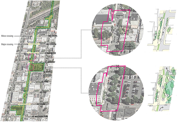
More permanent reimagined city streets are in the works. Landscape architects and urban designers are leading the charge in addressing these changing roles of public space. As an example, Mayer/Reed is working with the City of Portland to envision ways to implement the “Green Loop” along SE 6th Ave through the Central Eastside. The Green Loop is an urban design initiative adopted in 2018 to repurpose certain segments of rights-of-way for a linear park that connects and celebrates neighborhoods in the central city. In the section through Portland’s Central Eastside, our proposed design introduces much-needed broad canopy street trees and open space, as well as more generous places for people to walk, run, scoot and bike. The current streetscape activation that we are seeing now along 6th Ave just hints at the vision being designed for the forthcoming Green Loop that will encircle the downtown.
In the summer of 2020, we worked with Friends of the Green Loop, Bureau of Planning and Sustainability, and PBOT on a concept for uniting the existing Safe Street installations along the corridor with street paintings to infuse Green Loop identity while also collaborating with the adjacent artists and businesses.
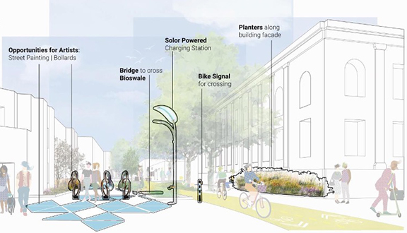
In addition to this work, I had the opportunity last fall to co-teach a landscape architecture studio for the University of Oregon focused on urban design in the post-COVID city. As a project, one group of students imagined the future of SE 6th Ave as a place that celebrates the district’s industrial roots, promotes a vibrant neighborhood, and expresses the creativity of the district’s businesses. They proposed new green spaces, flexible uses in the right-of-way and parking lots, an innovative bike delivery system, solar energy generation and spaces for art and artists. Stakeholders from the Friends of the Green Loop and the Central Eastside Industrial District collaborated with the students and are carrying some of these ideas forward.
As our cities continue to densify, there will be increased demand to support streets as places for people to linger and gather, rather than exclusively as places for people to move. A key to success will be finding the right balance and integration of placemaking and transportation. I can imagine a future where it will be possible to walk along SE 6th Ave and enjoy a mix of open spaces activated by adjacent businesses with spaces that are truly public, where you can experience the shade of a mature tree, comfort of a bench and conversation with a friend.